
Sistem Penentuan Titik Pengambilan Sampah Berdasarkan Status Berlangganan Menggunakan Peta Digital
Kata Kunci:
sistem pengelolaan sampah, sistem informasi geografis, pemetaan digital, layanan pengangkutan sampah, sistem informasi berbasis webAbstrak
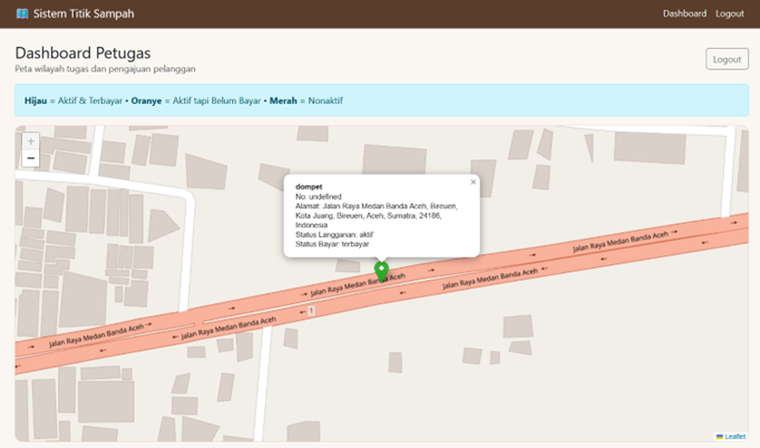
Penelitian ini bertujuan untuk merancang dan mengembangkan sistem berbasis peta digital dalam menentukan titik pengambilan sampah berdasarkan status berlangganan pelanggan. Layanan pengangkutan sampah di banyak daerah masih dikelola secara manual sehingga menyulitkan dalam memantau lokasi pelanggan, status pembayaran, serta penanganan komplain secara efisien. Untuk mengatasi permasalahan tersebut, penelitian ini mengusulkan sistem informasi berbasis web yang mampu mengintegrasikan data pelanggan, status pembayaran, pengelolaan komplain, serta visualisasi titik pengambilan sampah melalui teknologi peta digital. Sistem ini dikembangkan menggunakan teknologi web dengan dukungan basis data untuk menyimpan informasi pengguna, lokasi pelanggan, data pembayaran, serta pengajuan atau komplain layanan. Pelanggan dapat melakukan registrasi, menyimpan lokasi rumah menggunakan peta digital, melakukan pembayaran layanan sesuai kategori langganan, serta mengajukan komplain terkait layanan pengangkutan sampah. Admin memiliki hak akses untuk mengelola data pelanggan, menetapkan petugas pengangkutan, memantau status pembayaran, serta melihat sebaran lokasi pelanggan melalui antarmuka peta digital. Petugas pengangkutan sampah dapat melihat peta lokasi pelanggan yang menjadi tanggung jawabnya serta memberikan tanggapan terhadap komplain yang diajukan oleh pelanggan. Sistem ini bekerja secara otomatis dengan memanfaatkan data status langganan dan pembayaran yang tersimpan di dalam basis data. Visualisasi peta akan menampilkan status setiap pelanggan dengan indikator yang berbeda secara dinamis. Implementasi sistem ini diharapkan dapat meningkatkan efisiensi dalam pemantauan layanan pengangkutan sampah, membantu petugas dalam menentukan rute pengambilan sampah, serta meningkatkan kualitas pelayanan pengelolaan sampah kepada masyarakat.
Unduhan
Referensi
[1] D. Wildawati and E. Hasnita, “Faktor yang berhubungan dengan pengelolaan sampah rumah tangga berbasis masyarakat di kawasan bank sampah hanasty Kota Solok,” Jurnal Human Care, vol. 4, no. 3, pp. 149–158, 2019.
[2] N. U. K. Devi et al., “Implementasi Kebijakan Pemerintah dalam Pengelolaan Sampah melalui Program Bank Sampah di Kota Probolinggo,” Jurnal Penelitian Inovatif, vol. 4, no. 4, pp. 2509–2514, 2024.
[3] M. P. Wiranegara, “Strategi Berkelanjutan dalam Pengelolaan Sampah di Daerah Perkotaan yang Padat Penduduk”.
[4] I. W. Maesarini, D. R. Setiawan, and M. P. Dewi, “Strategi gerebek sampah pemerintah Kota Depok menuju kota bebas sampah tahun 2020,” Reformasi Administrasi, vol. 7, no. 2, pp. 107–112, 2020.
[5] K. N. geswari and K. P. Satamraju, “Efficient Garbage Management System for Smart Cities,” International Journal of Engineering Trends and Technology, vol. 50, no. 5, pp. 260–265, 2017, doi: 10.14445/22315381/ijett-v50p242.
[6] D. Ariadi and T. Tashid, “Prototipe Sistem Pengukur Ketinggian Permukaan Sampah Pada Tempat Pembuangan Sementara Menggunakan Arduino Dan Web Gis,” JOISIE (Journal Of Information Systems And Informatics Engineering), vol. 2, no. 1, pp. 18–25, 2018.
[7] W. Wahyudin, “Pemetaan Tempat Penampungan Sampah (Tps) Ilegal Menggunakan Geographic Information System (Gis) Di Wilayah Kecamatan Mataram Kota Mataram,” Jurnal Ilmiah MITSU (Media Informasi Teknik Sipil Universitas Wiraraja), vol. 7, no. 2, pp. 8–16, 2019.
[8] F. Setiawan, “Aplikasi penginderaan jauh dan GIS untuk penentuan lokasi TPA sampah di Kota Surabaya,” in Seminar Nasional Aplikasi Teknologi Informasi (SNATI), 2010.
[9] R. Irsa, R. Budiarni, and A. Budiman, “Pemetaan tempat pembuangan sampah di kota payakumbuh menggunakan mobile gis,” Simtika, vol. 3, no. 2, pp. 13–20, 2020.
[10] E. D. Putra, K. P. Utomo, and A. Sulastri, “Optimalisasi Sistem Pengangkutan Sampah Di Kabupaten Bengkayang Berbasis Geographic Information System (GIS),” Jurnal Teknologi Lingkungan Lahan Basah, vol. 11, no. 2, pp. 321–328, 2023.
[11] I. Muslem, I. Irvanizam, A. Almuzammil, and F. Johar, “Adaptive Heuristic-Based Ant Colony Optimization for Multi-Constraint University Course Timetabling with Morning Slot Preference for Energy Efficiency,” Jurnal Teknik Informatika (Jutif), vol. 6, no. 6, pp. 5930–5943, Jan. 2026, doi: 10.52436/1.jutif.2025.6.6.5588.
[12] V. Kumar, K. Yadav, and V. Rajamani, “Selection of Suitable Site for Solid Waste Management in Part of Lucknow City, Uttar Pradesh using Remote Sensing, GIS and A.H.P. Method,” International Journal of Engineering Research & Technology, vol. 3, no. 3, pp. 1461–1472, 2014.
[13] M. G. Perrina, “Literature review sistem informasi geografis (SIG),” Journal of Information Technology and Computer Science (JOINTECOMS), vol. 10, no. 10, pp. 1–4, 2021.
[14] E. Elfayetti, R. Rosni, N. Yenny, M. T. Rahmadi, and H. Herdi, “Analisis Laju Deforestasi Hutan Manggrove Menggunakan GIS di Kecamatan Percut Sei Tuan Kabupaten Deli Serdang,” Jurnal Ilmu Lingkungan, vol. 22, no. 3, pp. 565–570, 2024.
[15] M. Ridwan, “Pemetaan objek wisata alam kabupaten kepulauan selayar berbasis sistem informasi geografis arcgis 10.5,” Pusaka: Journal of Tourism, Hospitality, Travel and Business Event, pp. 45–50, 2019.
[16] S. Novianti, T. Nurkholifa, M. Suryana, and E. Susanto, “Penggunaan Geographical Information System (GIS) untuk Visualisasi Analisis Perilaku Spasial Wisatawan,” Journal of Indonesian Tourism, Hospitality and Recreation, vol. 4, no. 2, pp. 213–223, 2021, doi: 10.17509/jithor.v4i2.37168.
[17] M. D. Chaniago and H. M. Taki, “Geographic Information System (GIS) as an Information Media in the Field of Environmental Health: Literature Review,” Journal of Applied Geospatial Information, vol. 6, no. 2, pp. 641–646, 2022, doi: 10.30871/jagi.v6i2.4319.
[18] N. Latif, R. Arifin, and S. Rezki, “Sistem Informasi Geografis Pemetaan Dan Pengelolaan Bank Sampah Berbasis Web,” Ilmiah Ilmu Komputer, vol. 9, no. 1, pp. 46–50, 2023.
Unduhan
Diterbitkan
Cara Mengutip
Terbitan
Bagian
Lisensi
Hak Cipta (c) 2026 Jurnal Ilmu Komputer Aceh

Artikel ini berlisensiCreative Commons Attribution-ShareAlike 4.0 International License.
Jurnal ini adalah jurnal akses terbuka yang menyediakan akses langsung secara nasional, bebas hambatan ke teks lengkap dari semua artikel yang diterbitkan tanpa biaya pembaca atau institusi mereka untuk mengaksesnya. Pembaca berhak membaca, mengunduh, menyalin, mendistribusikan, mencetak, mencari, atau menautkan teks lengkap semua artikel di Jurnal ILKA. Jurnal ini memberikan akses terbuka langsung ke kontennya dengan prinsip bahwa membuat penelitian tersedia secara bebas untuk publik mendukung pertukaran pengetahuan global yang lebih besar.

